Paragliding companion · offline-first
Skybase answers the three questions every free-flight pilot has — then flies with you and keeps the record.
Built and flown by a working pilot. No accounts. Your data stays on your phone.
What Skybase is
Most pilots juggle a weather site, a separate vario app, a map, and a spreadsheet. Skybase brings the whole loop into one place: pre-flight weather & site intelligence, an in-flight instrument (audio vario, moving map, glide, XC), and an IGC logbook with replay — all working offline at the hill, tuned to your skill level, from student to advanced.
It's decision support, never a clearance. Every score, window, thermal and wind read is an aid — the reasoning is always shown so you can disagree with it. You make the go/no-go call and carry current charts.
Before you drive to launch
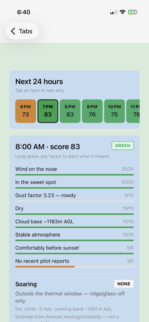
Open a site and see the next 24 hours at a glance — a plain-language read of the conditions, not just a number.
0–100 with green / yellow / red and a full factor breakdown: wind direction & speed, gust factor, precip, cloud base, overdevelopment, time to sunset. The reasoning is always visible.
Wind from a rotor quadrant, wind off the back, wind over the site's limit, storm-level instability, rain or cloud on the hill each force the hour red on its own — a nice day elsewhere in the forecast can't outvote them. Expect fewer green hours than a scoring average would give you; the ones you see passed every limit.
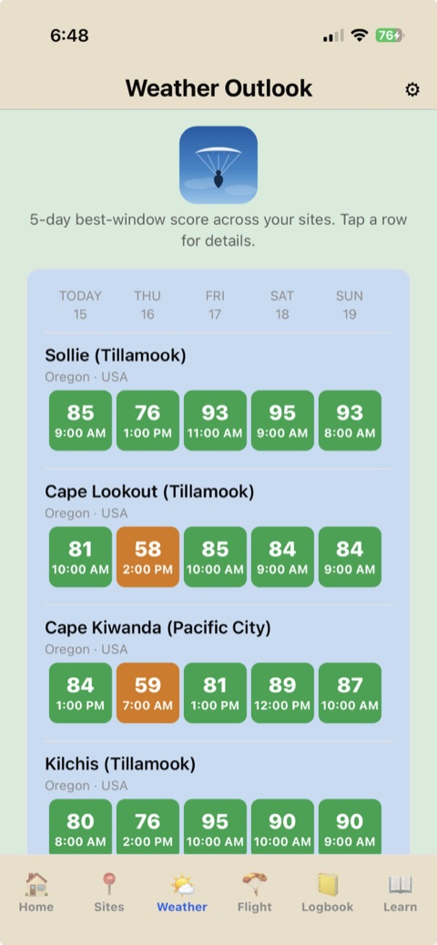
The longest workable daytime run — and it's daylight-gated, so a launch never suggests a 2 AM window. In the 5-day outlook, a day with no flyable hour goes red and names what stopped it — too windy, gusty, low cloud — instead of showing a blank you have to guess at.
Will there be lift or a sled ride? Estimated climb strength, the working band, and when thermals switch on and off. Labelled an estimate, because it is one.
Real anemometer readings from free community & government networks (Pioupiou + NOAA/NWS), closest-first, with reading age — ground truth to sanity-check the forecast.
Estimates the hike up to launch (distance + ascent → time) and tells you when to leave to make the flyable window before sunset.
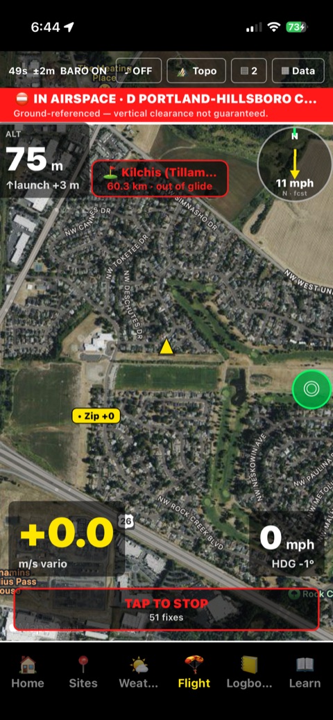
Loads real airspace zones and warns near them — advisory only, never a substitute for your pre-flight chart & NOTAM check.
A map of where you've actually cored lift near a site, built from your own logged flights (bigger & redder = stronger, ×count = times found) — plus nearby pilots' spots if you opt in. Tap any site map to open it full-screen.
Skill-aware: students get tighter wind/gust caps and more "explain this metric" help; advanced pilots get more headroom. Weather is free, global Open-Meteo data (no key), cached so it works offline at the hill.
In the air
Stow the phone and fly. The screen flips to a high-contrast flight theme with huge digits, big touch targets, and audio you don't need to look at.
Climb beeps with cadence and pitch, plus a tunable sink alarm — GPS + barometer fused through a Kalman filter that self-calibrates, GPS-only fallback when there's no baro. Test the tones on the ground from Settings — no GPS fix, no flight needed — so you set your volume before launch instead of finding out in the air.
The map rotates so your direction is always up — or lock it north-up, or zoom out to frame your whole route. A compass rose shows the wind so it still reads true. Recenter with one tap; pan to look around and it holds.
A final-glide reach cone and glide-to-nearest-landing readout — a free safety aid, always on.
Set a GOTO target or import a task (XCTrack .xctsk / SeeYou .cup); see distance, bearing, ETA and turnpoint cylinders in the air.
Choose which numbers ride the readout bar and their order, then long-press the bar — or the wind rose — to drag either anywhere on the map. Barometer status and live GPS accuracy sit right in the top strip with the map controls.
Keeps logging in the background so battery lasts. A one-time in-app disclosure explains exactly why it needs background location before it's ever asked for.
After you land
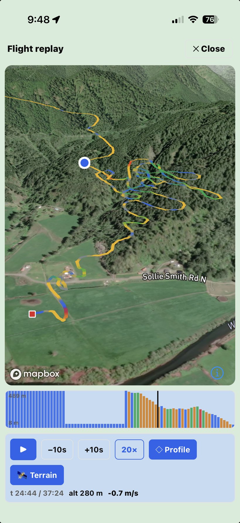
Every flight is saved as an IGC track — the sport's universal format — and comes to life in a full replay.
Press play and the track draws itself as it flew — the line reveals from launch to landing as the replay runs. Scrub a colour-coded altitude barogram, follow a tilted camera down your line, and tip into a 3D terrain view.
Send anyone a link to a flight and they watch your track replay with your stats right in their browser — no app, no account, works on any phone or computer. Perfect for the people at home who want to see where you went. You can stop sharing at any time, and links expire on their own.
Every flight is named with the site you flew — Skybase reads where your track starts and matches it to your own sites list, so there's nothing to fill in and old flights get their names too. Or name it yourself, and it can look up the site from your launch point (the nearest paragliding site or place from OpenStreetMap). Career totals — flights, air time, max altitude & climb, sites, distance, best XC — plus achievements as you hit milestones. Tap Sites to see every place you've flown on a map. Import flights from another instrument, or log one by hand if you flew without recording.
Stood at launch for a while with recording running? Trim the pre-launch wait — and any packing-up after landing — with a two-handle barogram that starts on the auto-detected launch and landing, showing the new duration and distance before you confirm. Recheck airtime does the same across your whole logbook: it scans, shows exactly what it would change, and waits for your OK. Trimming is always something you ask for and preview first — saving a flight never alters your track file.
An AI thermal forecast trained on your own flights — it predicts a day's climbs from your most similar past days, and grades its own track record honestly (no hindsight in the maths).
The in-flight co-pilot suggests what to do next. After you land, its report card shows how many of those tips you took and how many paid off — you were climbing again within two minutes. Safety warnings are counted but never scored right or wrong. No other flight app keeps honest score of its own in-air advice.
One-tap backup of everything — flights, sites, wings, routes and your IGC tracks — in one open file, then restore it on a new phone. Nothing left behind, no account required. Share any flight's IGC to SeeYou / XCSoar or your XC league too.
Every track is written to your phone the instant you tap Start — before anything else. So even if a flight somehow doesn't land in the logbook (a rare hiccup, or the app closed before you stopped), Skybase spots the leftover track and offers a one-tap “Recover” — with the real GPS trace and stats intact. A “Fix or recover a flight” button re-runs that check whenever you want, and tells you plainly what it found. And if a flying buddy loses their flight, you can send them their track back from what your phone recorded of them.
Safety — free, and never paywalled
The tools that keep you alive stay free forever. Sharing is always opt-in and off by default.
A site-aware checklist that resets overnight — so "did I do up my leg straps?" has an answer.
Track your wing, harness and reserve — and see each wing's lifetime flights, air time and distance, summed from the flights you flew on it. Get a local reminder before a reserve repack is due. New wing? Retire the old one to keep its whole history instead of deleting it.
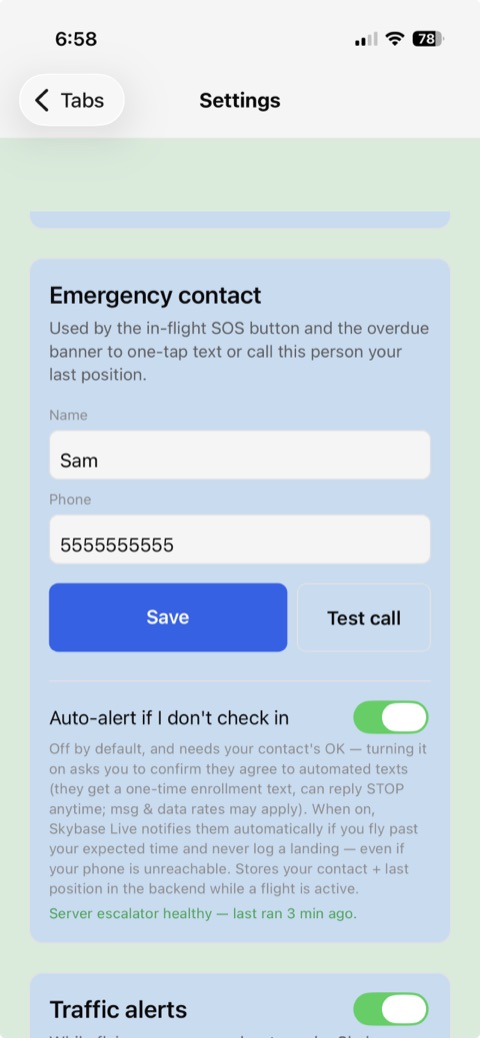
One tap texts your emergency contact your position. An optional overdue watch can auto-alert them if you don't check in after a flight — opt-in, with the contact's consent.
Share your live position with a private group and get converging-traffic alerts — but only from other Skybase pilots who are also sharing, not all air traffic. We say so, in the app.
Honest by design
Pricing Coming soon
Everything you need to fly — the instrument, sites, weather, logbook and every safety tool — is free forever. Subscriptions aren't live yet, so there's nothing to buy today; here's what Skybase Pro will cost when it launches.
$0 · forever
The full in-flight instrument (vario, map, wind), site intelligence & weather, your logbook and replay, and every safety tool — glide-to-nearest-LZ, manual SOS, the overdue banner. No account, no ads, no tracking.
$34.99 / year
or $5.99 / month · 7-day free trial on annual
Unlocks the cloud & advanced band: thermal soundings, XC route & navigation, live "watch me fly" tracking, the SOS auto-alert dead-man's-switch, plus buddy positions & crowdsourced conditions as your local community grows.
$24.99 / year · locked for life
Everything in Pro, at a price that never goes up for as long as you stay subscribed. For the first pilots on board — the first 100 annual members, or the first 90 days after launch. Get in early and you keep it.
Prices are in USD and shown for the upcoming launch; local store pricing may vary. The tools that keep you alive are free forever and never move behind Pro. Cancel anytime in your App Store / Google Play settings.
Get Skybase
Skybase is live on the App Store (iPhone) and Google Play (Android) — free, no account needed.
Available on the App Store
Download it free from the App Store — no account needed. Prefer to get new builds early? You can still join the TestFlight beta.
Available on Google Play
Download it free from Google Play — no account needed.
Both are free with no account needed — tap Download on the App Store or Get it on Google Play above. Prefer early builds? iPhone users can still join the TestFlight beta.
Available in 148 countries on the App Store — everywhere except the EU, which is coming soon. Google Play is expanding to match.
Good to know
It's a capable phone vario (GPS + barometer). For serious XC, treat it as a smart companion and carry a dedicated backup — the manual explains why.
Yes — the instrument, logbook, and cached weather all work offline. Live weather refresh and the opt-in cloud features need a connection.
No. There are no accounts and no login — everything works on-device the moment you install.
An independent developer and paraglider pilot — the app's first daily user — building it under the GetLostAdv brand (this site's domain).
 Skybase